
Cowesfield Lodge stands on the A27 at the entrance to the drive to Cowesfield House, opposite the Frogmere House pond and at the point where the road to Testwood Cottages leaves the A27. It dates from after 1773 and before 1842.
There is a second lodge of Cowesfield House at Dean Lodge on Miles Lane.
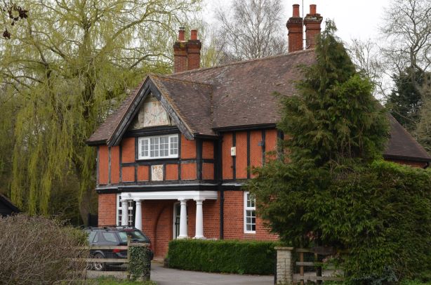
Cowesfield Lodge in March 2021
The house has some significant ornamentation under the west facing gable, above the drive to Cowesfield House, with elaborate carved stonework surrounding a painted bas-relief panel. A second bas-relief panel is mounted in the timber frame a little lower on the same face of the building.
 .
. 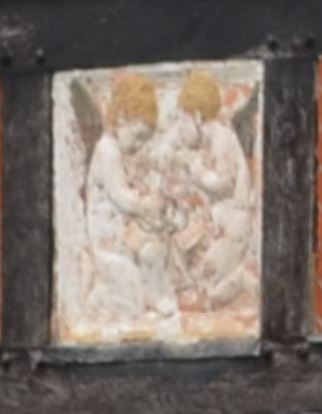
Cowesfield Lodge ornamentation LEFT: under gable, RIGHT: lower down on the wall
Cowesfield Lodge on old maps
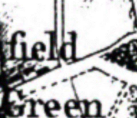
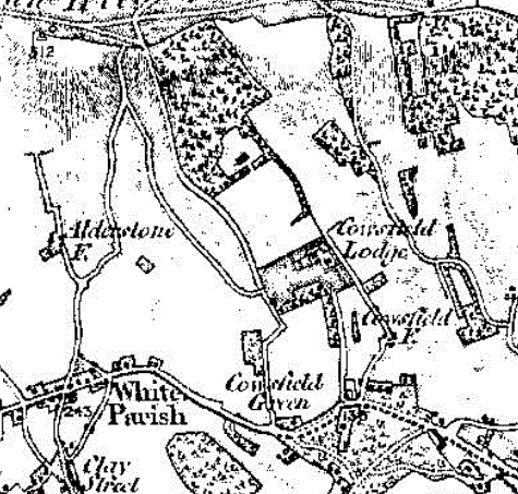
The earliest map we have showing the area around the lodge is the Andrews and Drury map of 1773. This shows the track coming from Cowesfield House and joining the turnpike road, now the A27, in much the same configuration as it has today. The position of the lodge is under the "d" of Cowesfield Green. Neither the lodge nor the pond is shown, but the amount of detail varies across the map, so this in itself isn't absolute proof that it wasn't there at the time. Other information below suggests that it wasn't built until after 1818.
We know that Cowesfield House was expanded from a farmhouse to a modest country house when Henry Dench bought it in 1767, just four years before the 1773 map, and a much grander expansion took place when Sir Arthur Paget bought the property in 1815. Taylor credits the "successors to the Pagets" with building "new lodges at the southern ends of the drives", although as usual we need to be careful not to place too much credence on Taylor's claims unless verified elsewhere. Indeed, the Cowesfield Lodge drive does have a south end, but Dean Lodge is at the west end of its drive, not the south. The Pagets were succeeded by George Lawrence in 1818, implying that Sir Arthur had owned the property and carried out all the improvements to the house in three years, leaving it entirely likely that adding the lodges would have fallen to George.
 Cowesfield Lodge Andrews and Drury map 1773, no lodge shown
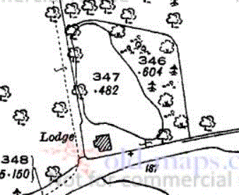
The first edition Ordnance Survey map (below) does show some detail consistent with the lodge and pond at the south end of the drive. Whether there is a house there too is not easy to determine. Note that on this map Cowesfield House is mislabelled as 'Cowesfield Lodge' - the lodge is further south on the north side of the A27, a little to the right of the words 'Cowesfield Green' and opposite the figures '13'.
1st edition Ordnance Survey 1 inch to the mile (1811 from survey 1797-1810 with later revisions up to 1870)
The label 'Cowesfield Lodge' is where Cowesfield House stands, not the lodge - see note above
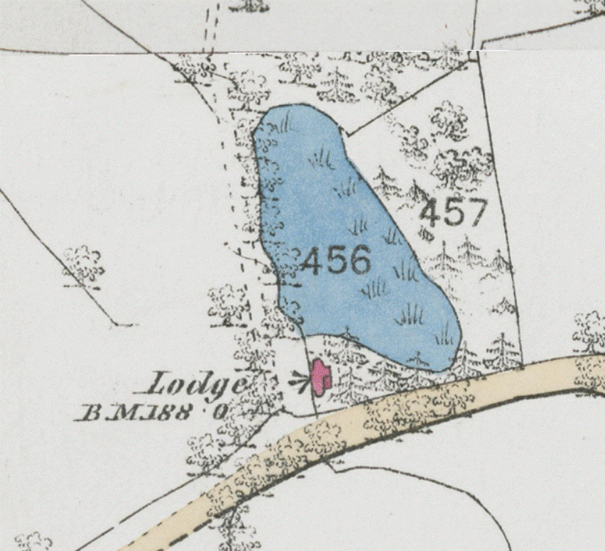
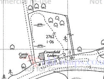
With the Tithe Map of 1842 (below) some clarity emerges. Parcel 165 on the Tithe Map is described as a Fish Pond, owned by George Lawrence, and the lodge is shown in red under the figures 166. As can be seen from the present pond across the road in the grounds of Frogmore House, the headwaters of the Parkwater flow strongly enough here to sustain a good pond. There is still a pond behind the lodge, mostly hidden under trees and rather smaller, but sometimes visible on satellite imagery. On this map the track to Cowesfield House follows the same line as it does today, with labels for Park Mead 123d, 123c and 123b shown alongside the pond on the east side of the track. 166 is called Lodge Plantation (Phoebe Merrick's tracing showed Lady Plantation), standing around the north, east and south sides of the pond. The presence of the lodge on this map shows that it might have been put there by Henry Dench or Sir Arthur Paget. George Lawrence died in 1861 aged 85 (church memorial, pictured here). George was followed by his wife Sarah Brissett Lawrence with inheritance then passing to his great-nephew William Frederic Lawrence (see George Lawrence). The 1st Edition Ordnance Survey 25" map (also below) dates from around the same time and shows the shape of the pond in more detail. Here the Lodge is drawn in some detail and cleary labelled, part of parcel 457.
 .
.  Cowesfield Lodge
LEFT: 1842 Tithe Award map - parcel numbers listed below); RIGHT: OS 1st Edition 25" map
123b Part of Park Mead, pasture, 6-1-11 (acres-roods-perches)
123c Part of Park Mead, pasture, 2-2-34 (deduced, 123 in Know Your Place database but no 123 on map)
123d Part of Park Mead, pasture, 4-3-28
165 Fish pond, water, 0-2-6
166 Lodge Plantation, wood, 0-2-21
The lodge itself doesn't seem to be listed in the Tithe Award database, neither is it separately numbered on the Tithe map
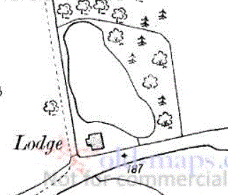
The 1:2500 Ordnance Survey map of 1886 again shows the lodge, albeit in less detail. The fish pond continues to be shown immediately behind it up to 1926 on these maps, but by 1966 it was just shown as marshy ground, and I've always assumed it is simply a garden today (2021) with a smaller pond remaining within it.
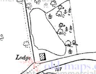 Cowesfield Lodge map 1886
If the detail on these maps can be relied on, the front extension to the Lodge with its grand pillars (and the gable roof above with the ornate decoration) was built between the 1886 and 1901 maps, so in the time of William Frederic Lawrence at Cowesfield House (1887-1907), so he can probably be credited with this particular extension. The outline of the rest of the lodge on this series of maps remains unchanged from 1901, so if it is shown accurately on the 1886 map then it would have been the present house without the gable and portico over the front door. The detailed shape of the lodge on the 1st Edition OS map isn't matched at 1886, so it may be that the lodge was rebuilt before 1886.
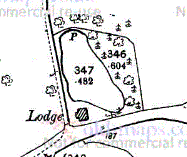 Cowesfield Lodge map 1901
 Cowesfield House Park 1909 map
 Cowesfield Lodge map 1926
 Cowesfield Lodge map 1966